Thursday, March 31, 2016

Sheffield

Sheffield main drag.
Some of the many murals on the buildings. 


One of the artists touching up his work.
The hotel where I had dinner.

Thursday, March 31st. continued:

Sheffield is a very pretty town. I saw some of the murals and decided to stay here. I got a motel room and then went back to the main drag to see more of the murals. This is the week of Mural Fest and there are a number of artists here painting murals in a competition. It was shutting down for the day, so I will check it out in the morning.

Then I went to the local hotel and had dinner and a beer before heading back to the room for the night.

Drove a total of 147 kms today.

The Walls of Jerusalem NP

The early morning sun on the farms and trees as I drove to the park.
Views on the hike.

The rock field where I bailed. I didn't want to climb that up to the top left corner.
Beautiful views and vegetation on the way down.

Remnants of recent bushfires that threatened the park this year.

Thursday, March 31st.
I was up early in my little room and left the hotel by 8:00. I popped into a local cafe, had a ham and cheese toastie and bought a sandwich and a muesli square for later. Then I drove through Mole Creek to find the The Walls of Jerusalem National Park. It took an hour and a half to get there. The entrance road started out paved and then degraded to dirt and the last ten kilometres were really rough and bumpy. There was evidence of recent bush-fires all along the road. I expected to find a visitor's centre and some information about hikes in the park, but the only thing they had was a small parking lot and a shed with a sign that told you to sign in but no book to sign in to. I was tempted to turn around and drive out, but I had heard that this was a great hike, so I decided to go.

At the beginning of the hike there was a sign that said the hike was 3-4 hours one way! And warned hikers to be prepared for changing conditions and to bring a compass and a map. I had neither. Anyway, I set out. The sign also said that the path rises about a kilometre 
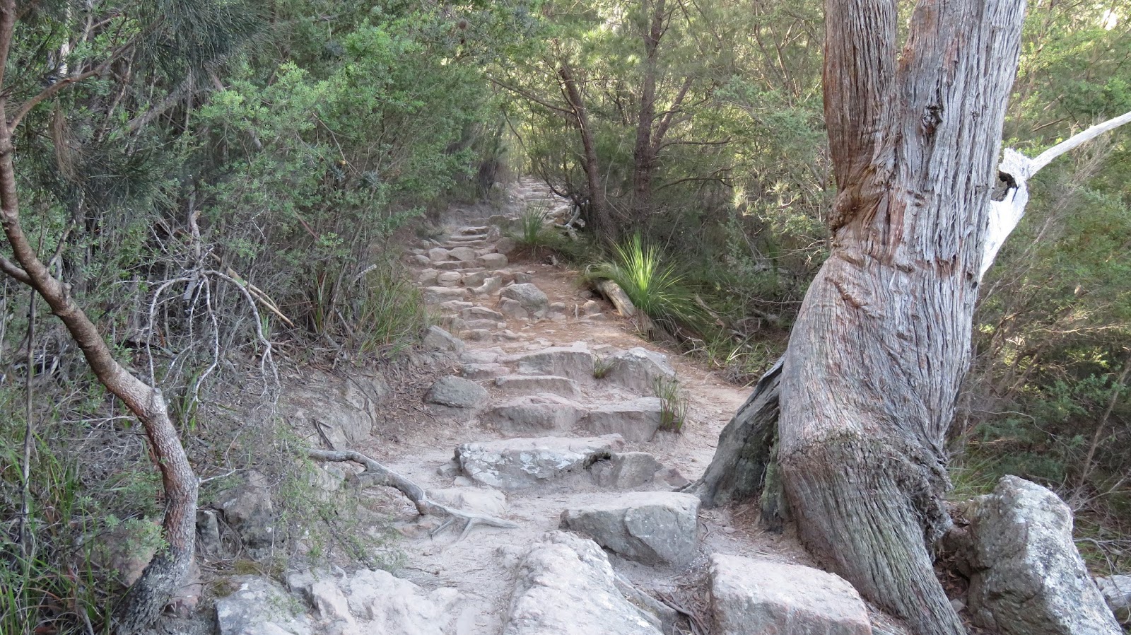
over the hike up to the western wall. The path was narrow and really rough, with lots of stones and rocks in it. I trudged on for a couple of kilometres before meeting two people who were coming out and a couple that I caught up to. The ones leaving gave us some tips about where to go and I walked with the other couple until they wanted to take a break and I carried on. 

The going was hard, uphill for a long time and then more level but treacherous underfoot. The terrain was very rugged even after it leveled off . The scenery was nice but there were not many big views until about two hours in. At that point I emerged from the bush and crossed a large more open alpine meadow and a marshy area where there was a wooden walking track. There must be lots of animals up here judging by the amount of droppings but I saw none. I think they are around in the evening. The only thing I saw was a small lizard. I also heard a lot of birds.

I hadn't seen anyone for a couple of hours and at the end the path split and went two ways. The only way was up an incredible rock fall and the other seemed to be leading down into another area. Neither route was marked with any sign telling your were to go and I was at a loss. I sat and ate my sandwich and then it started misting and raining lightly. Plus up here is was pretty breezy and the temperature was about 12. I was already three hours into the hike and knew I had to walk back out. Going up that slide was going to be very strenuous and potentially dangerous and would add more time I would have to retrace. I was also aware that I was wearing the wrong type of shoes. I wish I had brought my hiking boots because the little runners I was wearing don't offer enough ankle support. Anyway, you guessed it, I bailed and did not reach the end destination. I was disappointed, but ultimately it was the correct thing to do. Most people who do this hike are carrying over night backpacks, not doing a day trip.

The walk back was very tiring. It was long, rough ground and damp. Right at the end a dad and his two teenagers caught up to me and I talked to him for a bit. He told me they were in there for three days and had seen lots of animals.

When I finally got back to the car six and a half hours later, I was bushed. I drove back out of the park on the dirt road until I got back to the turnoff. Here I had to decide where to go and what to do for my last day in Tasmania. I had thought of going back to Cradle Mountain (about an hour away) and do another hike or the canyoning adventure, but I also want to get to the north-west shore of the state. I would like to come back to Tasmania and Cradle Mountain NP later in the year and do two hikes that I saw while there and the canyoning, in warmer weather, so I decided to turn east and headed back to Mole Creek to pick up a better road to go north. I found one that went to Sheffield and I remembered that Keith (from the b n b) had told me to go there because the town is covered in murals. The road was beautiful through picturesque farming valleys.

More on the next post. 

Wednesday, March 30, 2016

Mona and Freycinet National Park

 The entrance to MONA. It is all distorted metal that reflects everything.
 Wineglass Bay from the lookout. 
Some of the hundreds of steps.
 Wineglass Bay at the bottom of the hike.
 Cook's Bay.
Some of the locals.

Wednesday, March 30th.
I woke up earlier than I wanted this morning because of noisy neighbours leaving early to catch a flight, so I used the time to type up the last couple of days. Then I had the breakfast, packed up and left. I drove back through town to MONA. This is the largest privately funded museum in Australia (apparently funded with gambling money). MONA stands for Museum of Old and New Art. It is a complex of museum, winery, hotel, and bars. It is built on a peninsula and they have a large private (camouflaged) ferry that shuttles people from the city. You can also drive to it, which I did. The museum itself is built underground. The entrance is at ground level but as soon as you go in you take stairs (or a circular elevator) down three floors. The building is incredible and a work of art in its own right. The walls and ceiling are all different, at different angles and some of the walls are the cut bedrock. They tell you to start at the bottom and work your way up. They provide a smart phone with a GPS that locates you and tells you what piece of art you are looking at and some details. It also indicates if there is audio information as well and they provide you with headphones to listen to that. It also tracks your route and if you provide your e-mail they will send you all the information about what you saw.

The art itself is ancient (mummies and sarchagous), bizarre (a hall with plaster casts of about fifty vaginas), incredible (an overhead water fountain that spells out words with the water as it falls), and unfathomable (a video of two people with hugely bulbous, obviously fake noses and hands acting and arguing about something) and strange (a man with a totally tattooed back sitting on a bar stool type chair looking away from everyone. I asked and he sits for 5 hours with a break on the hour. I wonder is he the art or the artist?). Art is not my thing and I never go to galleries, but everyone who hears that you are going to Tasmania says you have to go here and I am glad I went, just to see the building if nothing else. I spent a few hours there and then headed out again.

I realized I don't have time to go to the Bruny Islands so I headed north to go to Frycinet National Park. This is where there is one of the world's most beautiful beaches that regularly shows up on the list of top ten beaches of the world. It is called Wineglass Bay.

I drove the Tasman Highway which is another scenic, under traveled, winding road through some very dry rural areas in brilliant sunshine. The east coast gets less rainfall than the west and is much drier. I arrived at Frycinet about two thirty and after checking out the visitor centre I took the steep two kilometre long hike to the Wineglass Bay Overlook. The view was spectacular, with turqoise water, white sand and mountains all around, but from this vantage point you cannot see the wineglass shape. I think it is really only visible from the air.

Since I had time and it felt good to be walking I decided to take the hike down the other side to the beach. It is all a steep descent (which means you have to climb back up). Down at water level it was very beautiful with the sounds of the waves, the colour of the water, sand and rocks. I walked around for a while before undertaking the ascent.

When I got back up, I drove back to the highway through Coles Bay where I stopped to buy a few things to eat. Then again conscious of positioning myself for tomorrow, I decided to drive as close as I could to Launceston. The roads were again winding and deserted. I finally reached the main highway from Hobart to Launceston. It was much more direct, flatter and 110 kms (which I could do). I drove to the town of Deloraine where I found a local bar/hotel that had a room for the night. It is a little divey room in an old hotel. I sat in the bar and typed for a bit, but the lady told me they were closing. What kind of bar closes at 9:30? I retired to my room and went to bed early for an early start tomorrow.

Drove a total of 451 kms today.

Tuesday, March 29, 2016

Port Arthur and Mt. Wellington

Port Arthur penal colony. 
 The ruins of the barracks.
The church were they tried to rehabilitate the convicts.
 The Tasman National Park coastline.
The Tasman Bridge in Hobart.


Hobart from the summit.

Tuesday, March 29th.
I got up and found out they had a buffet continental breakfast so I indulged before retracing my drive from last night towards Port Arthur. The drive was pretty and took about an hour and a half to get there. Port Arthur Historic Site is recognized by the World Heritage Foundation. It is a penal station that was established in 1830 as a timber getting camp, using convict labour to produce sawn logs for government projects. At the time Tasmania was called Van Diemen's Land. It was used from the 1830's until it closed in 1877. This colony was for repeated offenders, or escapees from other colonies. There was a large barracks for men and on an island off shore there was one for boys as young as nine. This was the beginning of juvenile reform in Australia.

I had a 40 minute guided walking tour and a half hour cruise around the lovely harbour. It was an interesting place with lot of buildings and ruins to explore, including the barracks, the prison and the large church, but I couldn't help feeling that it would not have been as nice when it was operating. Now it is very pretty and clean. I'm sure it was a horrible place in its day. They tried to rehabilitate the criminals who were mostly thieves and put them to work. There was a brick making factory, logging, boat building, farming and other shops.

After the cruise I decided to leave and drive back to Hobart. As the highway came over a hill it gave an incredible view of the Tasman Bridge. I spent a half hour driving around and trying to find the way up a pedestrian walkway over the highway from which to take a photo of it. In the process I found another small summit that gave a good view of the city. Finally I found the pathway and walked up. It was a great view. I had hoped to go to the Bruny Islands south of Hobart, but there was not enough time, so I decided to drive up Mt Wellington. Apparently Charles Darwin climbed up here well before there was a road!

What an incredible road up! This was another Depression era make work project that used unemployed WWI soldiers to construct a 10 kilometres long road up a very steep mountain. The summit above the tree line is quite large and flat and offers incredible views of Hobart and the surroundings. Really spectacular. I wandered around for a bit and then talked to two Australian men who told me some of the things I could see including the bridge I had photographed, and how an ore carrying ship had crashed into it one night in 1973 and caused part of the span to collapse! Then they had no bridge to connect the two sides of the city except for one about 20 kms away. When they rebuilt the bridge they built around the wreckage of the ship that sank right there with its cargo and the span of the bridge on top of it. The whole thing is below the water.

Then I drove back down and began to look for a hotel. I was tired and determined to find one earlier than the last couple of nights, but after a short look without luck, I decided to go back to the Travel Lodge. I knew where it was, that it was good and affordable and had a breakfast. I got there about seven, and spent the evening typing, watching the news and reading.

Drove a total of 266 kms today.

Monday, March 28, 2016

Strahan and Queenstown

Fishing boats in Strahan harbour.
Strahan town.
This is the beach outside of Strahan's harbour, expansive and very wild.
Queenstown
The road climbing out of Queenstown over the mountain with a 100 km speed limit!
One variety of gum tree.

Monday, March 28th.
I left early and drove to Strahan on the west coast. It was a beautiful sunny morning and the drive was scenic along very winding roads. The town of Strahan is very picturesque and a very touristy little town. There is an old steam railroad here that operates through the forests to Queenstown and a cruise along the River George, but I decided to take neither as I couldn't see what either would offer that I had not already seen from the road. This area was another British penal colony and the entrance to the bay is called Hell's Gate because of the desolation and misery suffered here by the convicts. I walked around town exploring and then headed out of town towards Queenstown and found a sign indicating the ocean beach. I went and checked it out and found a huge, deserted beach with wild surf.

Then I continued to drive towards Queenstown. Again the road was winding and scenic as I drove through the forests and up and over small mountains. When I got to Queenstown I noticed the devastation of the vegation in the area. This is a mining town where they mined copper and other minerals and smelted them here. But this was before we knew about the results of that. The whole area is dead from acid rain. I walked around the town which has many original wooden buildings and still looks like an old mining town. The mines are mostly shut down now. I checked out the railroad station which had the steam train in it that had just arrived from Strahan. I had a curried chicken pie and then drove out. The road out of town is very steep, winds around the mountains and is very narrow, but at the beginning they posted a speed limit of 100! Impossible! Most of the way I was lucky to hit 30. It wasn't for about 10 kms before the road crested the hills and became less treacherous.

From there it was a long drive through a huge naturally wild area of over a 100 kms. I decided to drive right to Hobart in order to better position myself for the last few days.


When I got to Hobart, I experienced my aversion to cities after being in the countryside for a few days, and decided to drive out of the city towards Port Arthur where I wanted to go the next day. I set the GPS to Sorrell on the outskirts of Hobart past the airport and set out. But I had no luck finding accommodation so I continued south east. Now it was getting dark and there were no people around. I drove on worrying a bit about animals on the road (there is lots of road kill here). I finally found a large beautiful old Hotel/Restaurant/Bar, but they didn't rent rooms! The lady phoned ahead to a hotel she knew but no answer. She told me that a lot of places were shutting down for the season, so I decided to head back. I retraced my steps for about 50 kms to the Hobart Airport where I knew there would be a hotel. Sure enough I found the Travel Lodge and booked in. Then I went to the gas station and Subway restuarant next door. I gassed up and ordered a small sub. There I met Michael (from Keith's b and b the other night)! He had just dropped off Natalia at the airport for her flight to Sydney. I sat and had dinner with him until he decided to drive home and I went to bed very tired.

I drove a total of 570 kms today.

Sunday, March 27, 2016

Cradle Mountain Hikes


 A wild echidna.
 Dove Lake and Cradle Mountain partly obscured by cloud at the end.
Glacier Lake and Wombat Pool.
 This is the type of grassy area that the wombats love.
A wild wombat.

Sunday, March 27th.
I got up, had a shower and then had breakfast with Michael and Natalia. Shortly after that they left and I got myself organized and took my leave too. Last night Keith said that he would like to come exploring with me but today he remembered he had made plans for Easter dinner with a neighbour. I think he is a pretty lonely guy.

It was a beautiful crisp day with incredibly blue skies. I decided to go to Cradle Mountain because I had heard that the weather up there was very changeable. I enjoyed a long drive on good roads with next to no traffic. On the way I stumbled across an echinda at the side of the road. I was able to get a number of great shots.

After driving for a couple of hours I arrived at Cradle Mountain National Park. I checked in at the visitor centre and read the list of available hikes of which there were lots. They have a 6 or 7 day overland hike that is rated as one of the best multiday hikes in the world. I talked to a guide about what hikes would be good for the day. He suggested the Dove Lake circuit and another short over land hike to the Ronny Creek car park.

So I bought a couple of drinks, a wrap and a couple of snacks and headed out. I took the park shuttle for the 20 minute drive to Dove Lake. Unfortunately the blue skies were gone and the top of Cradle Mountain was shrouded in cloud. I enjoyed the 6 km walk around the whole lake. The path was either rough gravel or a wooden boardwalk. There was a great view from a large glacial rock on the edge of the river. The path followed the shoreline and sometimes through patches of rainforest. Very enjoyable. At the end I stood and ate my wrap while watching the fog drifting around the summit. I would have loved to see it with clear blue skies.

Then I started on the other hike. This one was much more strenuous and had hundreds of steps up and down past a couple more lakes before arriving at the car park 10 kilometres later. Again this one went through some rain forest areas but at the end it crossed a meadow of large grass mounds with a small creek wandering through it. There I found about six wombats enjoying the grass. They weren't too bothered by me, so again I got some good photos.

I caught the shuttle bus back to the visitors centre. I talked to a couple of people who run an adventure company that takes people canyoning. This is like the kloofing I did in Cape Town. It looks like a great place and lots of fun but it is expensive and the weather definitely doesn't make me think of jumping into cold water with or without a wet suit.

I drove out of the park and turned west to find somewhere to sleep. I drove about 50 km along a good deserted road until I got to Tallum. Here I found a place called the Tallum Lake Front Lodge. They had a room and a diner on site. So I had dinner and a beer before retiring to my room to type up the last couple of days.

Drove a total of 208 kms today.

Bay of Fires

View along the highway to Launceston.

Beach and coloured rocks at the Bay of Fires.

Wonder what they are talking about...
Natalia, Michael and our host Keith

Saturday, March 26th.
When I woke up I found out the jacket had slipped during the night and landed on the face of the guy in the berth below, oops. The ferry arrived at Devonport at 8 instead of 6. I went to the tourist office and bought a pass to the national parks of Tasmania.

When I disembarked I drove to Launceston. This is where I have booked a bed and breakfast for the night. I decided to drive to the north east corner of Tasmania and go to see the Bay of Fire. This is a highly advertised area. The original European explorer named it that because of all the Aboriginal fires along the shore. I drove along some winding roads that traversed a small mountain range and then along a long dusty dirt road before reaching the Great Eastern Drive. I drove along the coast and stopped at a couple of beautiful beaches before I arrived at Binalong Bay, where there is a white squeaky sand beach and a section of coast littered with large boulders that are stained red and yellow, 
which is produced by a lichen. It reminded me of Georgian Bay.

From there I drove further south before turning west and driving back to Launceston. My phone had died and I didn't know the address of the b and b I had booked. So I drove around town fruitlessly with my computer on looking for free wi-fi. I tried my phone one more time. It started with only 1% power and thankfully stayed on long enough for me to find the address.


When I got there my host Keith met me at the door. He is a retired teacher who taught adults at a school for chefs. He is originally from Manchester England and his ex-wife lives a block away from where I live in Chelsea! He made me a roast chicken dinner and we talked about teaching, Tasmania and travels to other countries. He is an avid traveler and told me about some other places in India that he thought I should check out. While we were eating two other people arrived: Michael who is attending Maritime College of Australia here in Launceston to become a first mate on international ships and his girlfriend Natalia from Columbia, who lives in Sydney. Keith who is 72 met Michael at a pub on St Patrick's Day a week ago and invited him to come by, so he did. We all sat and talked until about 11 before retiring.

Drove a total of 550 kms today.

Saturday, March 26, 2016

The Spirit of Tasmania II

The ferry

Impossible to get a clear night shot with the boat vibrating!
My suite with three strangers.

Friday, March 25th,
It was raining when I woke up, so it was a perfect time to organize and pack. I gassed up the vehicle and packed up the truck. It cleared up in the afternoon and I went for a walk along the beach. When I went home I got an e-mail from the ferry service saying that the ferry would be boarding at 8 and leaving at 10, two hours later than scheduled. They also said there would be limited food on the boat and recommended that we eat before we arrive.

So I hung around a bit longer and then drove down to the ferry. I stopped in St Kilda and picked up a box of sushi and a drink. I had also packed a couple of bananas and apples that I had leftover for lunches. When I got to the ferry the line was long and very, very slow. When I finally got to the check in spot, they told me I couldn't take the fruit with me and because of the sushi I was given a quarantine sticker! That meant I had to consume the sushi on the boat and they would check with me when I got off the boat before I would be allowed to drive off into Tassie. The line was so long and so slow, I ate the sushi before I even got on the boat.


I finally boarded, parked the car and went up to the decks. I wandered around for a bit and went outside to see the lights of the city. Then I went and found my berth, which was in a room with two bunk beds. I met one of the other guys, another was already in bed. So I got ready and climbed in. I put my down jacket up by my pillow. I felt the boat rocking a bit, but I slept pretty well.

Friday, March 25, 2016

School Week 8

 500 students indoors for the end of term assembly.
 Joel leads them in Waltzing Matilda.
 Paul and Caroline
 Some of the French teachers celebrating with the French inspector.
 Anne and her 125cc Honda Rebel. I almost bought her husband's Indian motorcycle.
Nigel and I

Monday, March 21 to Thursday 24th.
Another good week at school. I rode the bicycle to school on Monday. The rest of the week I drove the CVR because I had to pick up Don's daughter Jennifer from his house and take her to school. We had arranged this because he has gone to Vietnam and she is in my class. I drive by his place anyway.
I finished my testing and organized the data in spreadsheets. The French teachers were all stressed this week as there was a French inspector in the school and they are all being evaluated.

On Thursday, we had an assembly at 2pm in the new building called the BDR. This is the open concept room where all the grade 5 and 6 classes are housed. There is a large open space and we managed to jam 500 kids in there for a end of term assembly. There were a few presentations with classes singing, or presenting a short play and then Joel led all the classes in the songs we had been practising during 'singing' time.

Christelle had arranged a social or choir practice after school, so I drove Jennifer home for the last time and went back to the Tree House pub for a drink with Christelle, Anne-Cecile, Anne, Claire, Leora, Caroline and her boyfriend Paul, Nigel and I. The French inspector came too and they all had a good time with him. We had a couple of drinks and a good time before we broke up for the holidays. I drove Nigel home, which was on my way. I got home about 8 and spent the rest of the evening organizing and planning for Tasmania.